Yikes
SAWHORSE
Google recently updated their aerial views of the Altadena fire. You can click on the heart of Altadena here:
https://maps.app.goo.gl/7PCKEvzjpywmdMhc6
County block after block of devastation - -nothing but ash heaps, lone chimneys, and a few remaining trees.
The fire actually started in Eaton Canyon, several miles to the east, here: https://maps.app.goo.gl/3bX7djBYkcAiMnBa6
Santa Ana winds typically blow from northeast to south/southwest, but on Jan. 6th they were whipping in many directions
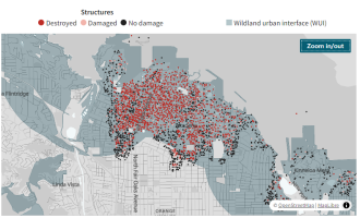
Here's a WUI map overlain with recent results of field surveys. Most of the lost structures were in the "intermix" zone.

Likewise, the Pacific Palisades area has been updated in Google Maps aerial View: https://maps.app.goo.gl/rjqmm1h7dakx8Vjg7
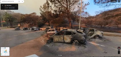
It is unsettling to toggle back-and forth between the "after" of these aerial views and the "before" street views, which still show everything as it was prior to the fire.
https://maps.app.goo.gl/7PCKEvzjpywmdMhc6
County block after block of devastation - -nothing but ash heaps, lone chimneys, and a few remaining trees.
The fire actually started in Eaton Canyon, several miles to the east, here: https://maps.app.goo.gl/3bX7djBYkcAiMnBa6
Santa Ana winds typically blow from northeast to south/southwest, but on Jan. 6th they were whipping in many directions
Here's a WUI map overlain with recent results of field surveys. Most of the lost structures were in the "intermix" zone.

Likewise, the Pacific Palisades area has been updated in Google Maps aerial View: https://maps.app.goo.gl/rjqmm1h7dakx8Vjg7
It is unsettling to toggle back-and forth between the "after" of these aerial views and the "before" street views, which still show everything as it was prior to the fire.
Last edited:


